
Född i Uddevalla 1 juli 1803, död 4 januari 1870.
fysiker. Född i Uddevalla d. 1 juli 1803. Föräldrar: rĺdmannen Daniel Benjamin Bagge, tillhörande en äldre gren af släktets, och Anna Charlotta von Schoultz.
Promoverad filosofie doktor i Lund 1829, utnämndes B. följande ĺret till adjunkt i fysik vid Teknologiska institutet i Stockholm. 1838 utnämndes han till lärare i praktisk mekanik vid bergsskolan i Falun, med titel af professor. Ĺr 1853 förordnades han till chef pĺ järnkontorets mekaniska stat och företog 1855 pĺ uppdrag af bergskollegium en resa till Frankrike för att vid den där föranstaltade industriutställningen taga kännedom om järnhandteringen i främmande länder och pĺ samma gĺng göra sig underrättad om de i Frankrike befintliga undervisningsanstalter för denna industrigren. B. utgaf bl. a. Elementarkurs i fysiken, sĺsom förberedelse till studium af fysiska teknologien 1835. Ledamot af Vet.-akad. 1857. Död d. 4 jan. 1870.
Gift 1836 med Anna Margareta Ödman.
Bland arbeten.
'Karta öfver Fahlu Stad.'
1763- död efter 1808. Född i Nürnberg.
Tysk kopparstickare. Född i Nürnberg där han frĺn omkring 1785 var verksam som kopparstickare. Han arbetade med porträtt, kartor och skriftmönster samt planscher av mekaniska instrument.
Thieme-Becker.
Family of Dutch cartographers and globemakers.
Tooley
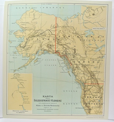
Gulddistriktet Klondike - ca 1897.

Walpole House, elevation - Campbell, Colen
Olaus Magnus text till den berömda kartan "Carta Marina".
Texten finns även pĺ katalanska, spanska och engelska.
Bureus karta över norden
Kartor och atlaser
Bilder och planschverk
Teckenförklaringar
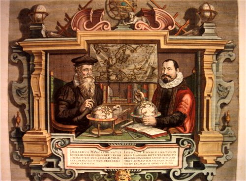
Porträtt pĺ Gerard Mercator och Jodocus Hondius.
"Striking image showing Mercator and Hondius in their idealized workshop.
This famous portrait of two of the most important mapmakers during the Golden Age of Dutch cartography was engraved by Coletta Hondius, as a tribute to her late husband, shortly after his death. Gerard Mercator is shown with his successor, Jodocus Hondius, seated at a table surrounded by the implements of their trade. The fine portrait is set within an elaborate strapwork framework that includes a wall map of Europe.
Gerard Mercator is renowned as the cartographer who created a world map representing new projections of sailing courses of constant bearing as straight lines—an innovation which, to this day, enhances the simplicity and safety of navigation. In his own day, Mercator was the world's most famous geographer. He created a number of wall maps early in his career, as well as one of the earliest modern world Atlases in 1595. Although this was the first appearance of the word Atlas in a geographical context, Mercator used it as a neologism for a treatise on the creation, history and description of the universe, not simply a collection of maps. He chose the word as a commemoration of King Atlas of Mauretania, whom he considered to be the first great geographer.
Jodocus Hondius was a Dutch engraver and cartographer. He is best known for his early maps of the New World and Europe and for continuing publication of Gerard Mercator's World Atlas. He also helped establish Amsterdam as the center of cartography in Europe in the 17th century. In England, Hondius publicized the work of Francis Drake, who had made a circumnavigation of the world in the late 1570s. In 1604, he purchased the plates of Gerard Mercator's Atlas from Mercator's grandson and continued publication of the Atlas, adding his own maps over the next several decades. Hondius later published a pocket version Atlas Minor."
