
1600-1684.
One of Sweden's first surveyors. Worked in the provinces of Östergötland and Värmland.
Sveriges sjökartor – A. Hedin.
Keere, Pieter van den [Kaerius, Petrus]
1571-c. 1646.
Pieter van den Keere was one of a number of refugees who fled from religious persecution in the Low Countries between the years 1570 and 1 590. He moved to London in 1584 with his sister who married Jodocus Hondius, also a refugee there, and through Hondius he undoubtedly learned his skills as an engraver and cartographer. In the course of a long working life he engraved a large number of individual maps for prominent cartographers of the day but he also produced an Atlas of the Netherlands (1617-22) and county maps of the British Isles which have become known as Miniature Speeds, a misnomer which calls for some explanation.
In about 1599 he engraved plates for 44 maps of the English and Welsh counties, the regions of Scotland and the Irish provinces. The English maps were based on Saxton, the Scottish on Ortelius and the Irish on the famous map by Boazio. These maps were not published at once in book form but there is evidence which suggests a date of issue (in Amsterdam) between 1605 and 1610 although at...
Död 1597.
Holländsk sjöfarare som ledde flera expeditioner för att finna en nordlig sjöförbindelse med Kina (Nordostpassagen). Sommaren 1594 nĺdde han Novaja Semljas västkust och följde denna norrut till 77:e breddgraden. Ett annat skepp i expeditionen seglade genom Vaigatsjstredet och hittade isfritt hav vidare längs nordkusten av Asien. En ny expedition ĺret efter hittade emellertid denna passage blockerad av packis och tvingades vända. Pĺ sin tredje expedition 1596 hittade Barents Björnön och upptäckte Svalbard som inte tidigare varit känt sedan vikingarnas resor dit. Frĺn Svalbard fortsatte han till Novaja Semlja och seglade runt nordspetsen av ön, där expeditionen blev den första att övervintra i Norra Ishavet. Dĺ skeppen följande vĺr inte kom loss frĺn isen tvingades manskapet överge dessa och färdas vidare i öppna bĺtar. Efter stora ansträngningar nĺdde de flesta fram till Lappland där de blev räddade, men Barents själv och flera andra omkom under resan.
Barentsz was a noted pilot who was convinced by t...
Salmonsen.
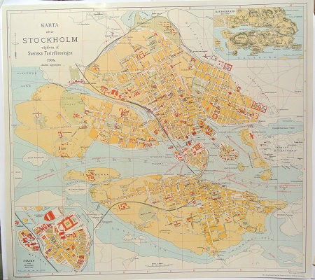
Karta öfver Stockholm. - 1904.

Knappsäv, Scirpus palustris - Lindman, C. A. M, Bilder ur Nordens Flora 1917-26.
Olaus Magnus text till den berömda kartan "Carta Marina".
Texten finns även pĺ katalanska, spanska och engelska.
Bureus karta över norden
Kartor och atlaser
Bilder och planschverk
Teckenförklaringar
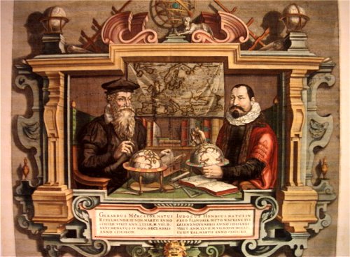
Porträtt pĺ Gerard Mercator och Jodocus Hondius.
"Striking image showing Mercator and Hondius in their idealized workshop.
This famous portrait of two of the most important mapmakers during the Golden Age of Dutch cartography was engraved by Coletta Hondius, as a tribute to her late husband, shortly after his death. Gerard Mercator is shown with his successor, Jodocus Hondius, seated at a table surrounded by the implements of their trade. The fine portrait is set within an elaborate strapwork framework that includes a wall map of Europe.
Gerard Mercator is renowned as the cartographer who created a world map representing new projections of sailing courses of constant bearing as straight lines—an innovation which, to this day, enhances the simplicity and safety of navigation. In his own day, Mercator was the world's most famous geographer. He created a number of wall maps early in his career, as well as one of the earliest modern world Atlases in 1595. Although this was the first appearance of the word Atlas in a geographical context, Mercator used it as a neologism for a treatise on the creation, history and description of the universe, not simply a collection of maps. He chose the word as a commemoration of King Atlas of Mauretania, whom he considered to be the first great geographer.
Jodocus Hondius was a Dutch engraver and cartographer. He is best known for his early maps of the New World and Europe and for continuing publication of Gerard Mercator's World Atlas. He also helped establish Amsterdam as the center of cartography in Europe in the 17th century. In England, Hondius publicized the work of Francis Drake, who had made a circumnavigation of the world in the late 1570s. In 1604, he purchased the plates of Gerard Mercator's Atlas from Mercator's grandson and continued publication of the Atlas, adding his own maps over the next several decades. Hondius later published a pocket version Atlas Minor."
