
Bland arbeten.
Plan de la ville de Peking levee en 1817 (title repeated in Russian). St. Petersburg, (c. 1815) 1220 x 960 mm.
A rare map of the city published in St Petersburg in the early part of the nineteenth century. The plan shows details of the city walls, gates, streets, waterways, lakes, palaces, buildings and temples. Although mentioned in Cordier, little detail is given, but it does appear to be a source map for a number of subsequent maps published through the nineteenth century.
The Russian Ecclesiastical Mission in Peking was founded in 1727. The Emperor KĺAng His gave them a temple in the north-west corner of the city. According to Cordier a good deal of Scientific and Sinological work was done at the mission.
Pň mitten av 1800-talet var panoramabilder av stadsmotiv en omtyckt konstnńrlig genre. Fň bilder har dock blivit sň omtalade Neuhaus' stockholmspanorama frňn 1870-talet. Och anledningen ńr inte sň svňr att f÷rstň. Sńllan har en karta utarbetats med sňdan omsorg och pedantisk noggrannhet.
Heinrich Neuhaus, en tysk fńrglitograf, kom till Stockholm i samband med fńrglitografins genombrott i Sverige pň 1850-talet. Han bevisade snart sin skicklighet och fick i uppdrag att utf÷ra ett Stockholms-panorama som skulle ÷vertrńffa f÷regňngarnas i frňga om detaljrikedom och exakthet.
Som underlag hade han en 'platt' stadskarta som Topografiska Corpsen utf÷rt 1862-67 och som i kompletterat skick utgavs 1870. Till detta hade han sň fotografier av en del centrala stadsportar och ritningar av fasader. Men det rńckte inte.
F÷r att kunna l÷sa problemet med det h÷ga flygperspektivet mňste han ocksň se vad som g÷mdes innanf÷r fasaderna. Och dň fanns det bara ett sńtt - att sjńlv bes÷ka varenda bakgňrd i staden och teckna...
VISSCHER, CLAES (eller NICOLAS ) JANZON.
1586-1652. F÷dd och d÷d i Amsterdam.
Hollńndsk kartograf. Gick i lńra som kopparstickare och kartritare hos Jodocus Hondius och grundlade dńrefter sitt eget konstf÷rlag. Visscher var en duktig kopparstickare, som f÷rutom kartor ńven utf÷rde landskaps- och historiska bilder. Hans firma ÷vertogs av sonen Nicolas (1618-79) och senare sonsonen Nicolas Visscher (se denne). Deras firma gav ca. 1660 ut en 'Atlas Contracuts' och ca. 1680 en 'Atlas minor' som bňde kom i en rad utgňvor. Deras kartplaner anvńndes ocksň i stor utstrńckning av andra kartutgivare, bňde i Holland och andra lńnder. Kartor av den ńldre Visscher rńknas som ganska sńllsynta. Han upptrńder vanligtvis under sitt latinska namn Nicolaus Joh. Piscator.
Claes Jansz. ging rond 1608 in het huis 'Op de Kolck inde Visscher' wonen. In het begin lag de nadruk op het versieren van de kaarten van Blaeu en Hondius. Later begon hij zijn eigen drukkerij en startte ook met de productie van kaarten. In 1611 kocht hij een huis in de gerespecteerde Kalverstraat, waar ook belangrijke concurrent...
Bland arbeten.
Atlas Contracuts.
Atlas minor.
Nederl. biogr., VII. - Tooley.
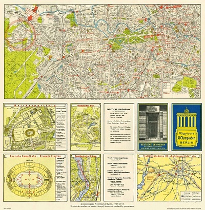
Vńgvisare f÷r XI Olympiaden i Berlin - 1936

'Kyt÷ - Tall÷rn' - Finland 1934.

Biografiska uppgifter:KÔtip ăelebi, Mustafa bin Abdullah, Haji Khalifa or Kalfa, (1609, Istanbul ľ 1657 Istanbul)
KÔtip Celebi was an Ottoman scholar. A historian and geographer, he is regarded as one of the most productive authors of non-religious scientific literature in the 17th century Ottoman Empire. Among his best-known works is the Kashf al-?un?n Ĺan as?m? al-kutub wa-al-fun?n, ('The Removal of Doubt from the Names of Books and the Arts'), a bibliographic encyclopaedia, written in Arabic, which lists more than 14,500 books in alphabetic order.
Life and works
The son of a soldier, he himself was a soldier for ten years until a heritage made him turn to a more contemplative life. As the accountant of the commissariat department of the Ottoman Army in Anatolia, he accompanied the Ottoman army in the campaign against Baghdad in 1625, was present at the siege of Erzurum, and returned to Istanbul in 1628. In the following year he was again in Baghdad and Hamadan, and in 1633-34 at Aleppo, whence he made the pilgrimage to Mecca (hence his title Hajji). The following year he was in Erivan and then returned to Constantinople. Here he obtained a post in the head office of the commissariat department, which afforded him time for study. He seems to have attended the lectures of great teachers up to the time of his death, and made a practice of visiting bookshops and noting the titles and contents of all books he found there.
One of his shorter and more accessible works is M?z?n al-?aqq f? ikhtiy?r al-a?aqq ('The balance of truth in the choice of the truest'), a collection of short essays on topics in Islamic law, ethics, and theology, in which he takes a relatively liberal and tolerant viewŚoften critical of narrow-minded Islamic religious authorities. This book serves as a source on Ottoman social developments in the 16th and 17th centuries, such as the introduction of coffee and tobacco. While he did not concur with the outlawing of coffee and tobacco, he found tobacco smoke personally distasteful, writing of the 'noxious effects of the corruption of the aerial essence.' An English translation by G. L. Lewis of the M?z?n al-?aqq has been published with annotations under the title The Balance of Truth.
Katip ăelebi died suddenly and peacefully in October 1657, while drinking a cup of coffee.
Bland arbeten:
CihannŘma (The mirror of the world) Constantinople, Ibrahim MŘteferrika, 1732. First edition.
This is the second work by KÔtip Celebi published in 1729. The author was a well known writer on history and geography and a bibliophile and in this work intended to publish a universal system of geography. In fact only part of the work (including the description of Asia Minor) was completed by KÔtip who used European and Arabic and Persian sources, and the whole was supplemented and edited by Ibrahim, who dedicated it to the grand vizir of Sultan Mahmud II, Ali Pasha.
The picture is showing the map of the Indian Ocean and the China Sea that was engraved in 1728 by the Hungarian-born Ottoman cartographer and publisher Ibrahim MŘteferrika; it is one of a series that illustrated Katip ăelebiĺs Cihannuma (Universal Geography), the first printed book of maps and drawings to appear in the Islamic world.
- Se bild.
