
HENRIK SJÖFARAREN, HENRIQUE EL NAVEGADÔR.
1394-1460.
Portugisk prins som runt 1430 lät inrätta ett kartografiskt centrum i södra Portugal. Var 'den store vägrödjaren som slutade med upptäckandet av sjövägen till Indien.'
Svensk uppslagsbok.
Carl Van Verden (fl. c. 1718 - 1730) was a Dutch seaman in the employ of the Russian Navy during the early 18th century. Van Verden is best known for his important 1719 - 1721 mapping of the Caspian Sea, which was the most sophisticated and accurate that had been issued to date. A significant cartographic achievement, Van Verden's work on the Caspian led directly to Peter the Great's 1722 invasion of Baku and Derbent and Russian hegemony in the region. Despite his achievements in the Caspian, Van Verden was later passed up by the Tzar in favor of Vitus Behring for the commission to discover a Northeast Passage through the Russian Arctic.
Around 1718 the Russian Tzar, Peter the Great, sponsored a number of cartographic expeditions to the farthest reaches of his vast empire. Most of these were headed up by Dutch navigators, the most experienced and mercenary of the era. Carl Van Verden, a Dutch seaman, was commissioned as a Russian naval officer and assigned the task of mapping the Caspian Sea. Though we...
Bland arbeten.
Carte Marine de la Mer Caspiene.
Född 1732 15/1 i Valsberga, Ĺkers sn (Söd.), död 1797 4/11 pĺ Brĺtorp i ovann. sn.
Kommissionslantmätare. Kartgravör. Son av kronolänsmannen Olof Ĺ. och Maria Ekström. Student vid Uppsala universitet 1754. Blev sedan enligt egen utsago »informator hos löjtnant Ridderhjerta, dels ock vid Kungsör hos slottsinspektoren Jesper Petrseus att informera dess dotterson Jesper Gillberg, hvarmed fortsattes till 1756. Ĺr 1757 antog jag station hos akademigravören Ĺkerman, hvilken jag hjälpte med gravyr af bokstäfver, sĺ att jag fanns skicklig gravera alla namn, som stĺ pĺ den första här i riket utgifna jordgloben med en fots diameter, fast jag ej fick hedern att mitt namn sattes pĺ globen» (EKSTRAND). Kommissionslantmätare 1781. Ägde Brĺtorp.
Bland arbeten.
A. BERCH, Oeconomisk beskrifning öfver Wadsbo härad uti Westergöthland och Skaraborgs höfdingedöme, diss., resp. G. F. Bergman, Uppsala 1759: karta över Vadsbo härad.
Karta över Tveta härad i Smĺland. 17601.
Stockholms magazin, 1780: striden vid Brunnbäck jämte karta över Grytnäs och Folkärna socknar, efter G. Halstenson 1652.
Svenskarna under Wilhelm Carpelan förstöra den preussiska flottiljen i Frisches Haff 1759, efter C. Rutensparre, kpst.
Hultmark, 1944.
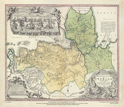
Ingermanlandiae – Homanns Erben 1734

Fleetwood - C. H. Tersmeden ca 1900.
