
(c. 1596, Neuhausen, – 1665, Hoorn)
Cellarius was a Dutch-German cartographer, best known for his Harmonia Macrocosmica of 1660, a major star atlas, published by Johannes Janssonius in Amsterdam.
He was born in Neuhausen (now a part of Worms), and was educated in Heidelberg. The Protestant Cellarius may have left Heidelberg at the onset of the Thirty Years' War in 1618 or in 1622 when the city came in Catholic hands. His activities are unclear at this time but based on his later works it is conjectured he spent time in Poland and may have even worked as a military engineer there. In 1625 he married Catharina Elt(e)mans in Amsterdam, where he worked as school master of a Latin School. After a brief stay in The Hague, the family moved to Hoorn. From 1637 until his death he was rector of the Latin School in Hoorn, where Pieter Anthoniszoon Overtwater was conrector.
He published on fortification and on Poland.
The minor planet 12618 Cellarius is named in his honour.
Andreas Cellarius
The Dutch-German mathematician and cosmogr...
Bland arbeten.
Harmonia macrocosmica sea atlas universalis et novus. Amsterdam: G. Valck and P. schenk, 1708.
Folio (530 x 320mm), allegorical title engraved by F. H. van Hoven, printed in red and black with woodcut vignette, letterpress title with contents and 29 double-page engraved cosmographical charts finely coloured by hand, without text.
One of the most fascinating achievement from the golden age of Dutch cartography. The Harmonia macrocosmica is the only atlas of the period dealing with astronomy.
Unlike the late celestial atlases, the Cellarius charts demonstrated various ancient and contemporary cosmological ideas, rather than just the names and positions of the stars. The purpose of the book was to assess different attempts to discover the underlying harmony of the universe. The charts represent the highest levels of seventeenth-century astronomical thought, with the diagram showing aspects of the three great theories on the nature of the universe; the Ptolemaic, the Copernican and the Brahean.
1603-56
JUSTUS DANKERTS (son) 1635-1701
The Dankerts family, of whom the above were the most important, was very large and ramifying having had a lot of members who were active in engraving on an artistic level. In this short view, however, we are dealing mainly with those who took part in the atlas production.
The family’s roots can be traced back to Cornelis Danckerts (1536-1595), a carpenter in Amsterdam. From his marriage with Lijsbet Cornelisdr two sons are known: Cornelis Danckerts de Rij (1561-1634) and Danckert Cornelisz (ca. 1580-1625). Cornelis and his descendants called themselves Danckerts de Rij. Danckerts Cornelisz who is at the root of the line we are now interested in was first a skipper then a stone merchant. He married Lijstbeth Jansdr, shortly after the turn of the century. Several members of his branch were well-known engravers-etchers, mapmakers and printsellers (Keuning, 1955). Danckert Cornelisz had two sons: Cornelis Danckerts (1603-1656) and Dancker Danckerts (1614-?).
Cornelis the elder brother established himself as...
Lantmätare. Det blev först under 1670-talet som riksrĺden i Stockholm blev ordentligt medvetna om nödvändigheten av en genomgripande kartläggning utförd av lantmätare i de erövrade Östersjöprovinserna. Denna hade dittills skötts utifrĺn Riga. Men 1678 inrättades ett kontor i Narva. Genom att det delade lokalitet med fortifikationskĺren, kom karteringen av hela omrĺdet kring Finska vikens inre mot Ladoga att ske blandat civilt och militärt. Resultatet av denna gemensamma ansträngning blev en stor karta över Kexholms län - Ingermanland, som i dess slutliga, av lantmätaren A. Andersin renritade, skepnad visades pĺ utställningen genom Kungl. Bibliotekets försorg. Denna karta frĺn 1699 lät tsar Peter snabbt överföra till kopparstick av Adriaan Schoonebeck 1704.
Bland arbeten.
Karta Kexholms län - Ingermanland.
Kart & Bildteknik 2003:3, artikel Frĺn Nyen till Hiddensee. Svensk kartläggning under 1600-talet. Av Ulla Ehrensvärd.
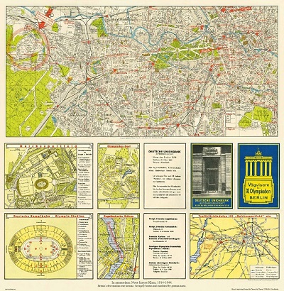
Vägvisare för XI Olympiaden i Berlin - 1936

'Danubii... Graeciae et Archipelagi' - Johann Baptist Homann ca 1710.
