
WERGELAND, HARALD NICOLAI STORM.
1814-93. Född i Bergen, död i Christiania (Oslo).
Norsk officer. Tog examen 1831 vid Krigsskolan, år 1849 blev han kapten i artilleribrigaden, 1852 överstelöjtnant vid Generalstaben, 1856 överste och chef för 'Kristiansandske infanteribrigaden'. Under åren 1857-60 var han chef för Generalstaben i Norge och 1859 blev han utnämnd till generalmajor och var 1860-68 chef för norska armédepartementet. Efter att ha tagit avsked som statsråd blev han chef för '2:a Akershusiske infanteribrigaden' och 1875 utnämnd till generallöjtnant. Från 1840 var Wergeland under några år anställd som trigonometrist vid 'Norges Geografiska Opmaaling'. 1849 deltog han i norsk-ryska gränsdragningen. Waligorskis och Wergelands vägkarta utgavs första gången 1847 och kom fram till 1893 i 8 nyutgåvor. Wergeland var ofta anlitad i militärt organisationsarbete och var dessutom den förste medlemmen i 'Norsk Jaeger- og Fiskerforening'.
Halvorsen.
1727–1795
One of the most important cartographers of the late 18th century.
In 1773 Bonne succeeded Jacques Nicolas Bellin as Royal Cartographer to France in the office of the Hydrographer at the Depôt de la Marine. Working in his official capacity, Bonne compiled some of the most detailed and accurate maps of the period. Bonne’s work represents an important step in the evolution of the cartographic ideology away from the decorative work of the 17th and early 18th century towards a more detail oriented and practical aesthetic. With regard to the rendering of terrain Bonne maps bear many stylistic similarities to those of his predecessor, Bellin. However, Bonne maps generally abandon such common 18th century decorative features such as hand coloring, elaborate decorative cartouches, and compass roses.
While mostly focusing on costal regions, the work of Bonne is highly regarded for its detail, historical importance, and overall aesthetic appeal.
Bland arbeten.
'Partie Occidentale du Canada'
Bland arbeten.
Encyclopédie ou dictionnaire universel raisonné des connaissances humaines.
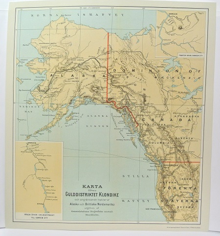
Gulddistriktet Klondike - ca 1897.

Daga Härad - 1905.
