
Fransk geograf i slutet av 1700-talet. Det finns en rad enkla kartor av honom frĺn ĺren 1753-91 men ingen hel atlas. Titeln geograf anger han själv pĺ kartorna. Inga ytterligare upplysningar om honom har funnits, om han inte är identisk med Jean Francois Augustin Janvier de Flainville (1717-91), som var advokat till 1759, inspektör vid krigsakademin vid revolutionen 1789 och senare borgmästare i Chartres och dessutom känd arkeolog.
Nouv. biogr. gen. - Phillips. - Tooley.
John: 1641-1708.
Samuel: before 1703-1739.
As a map engraver and hydrographer, Thornton was one of the best-known figures of his time, being appointed Hydrographer to the Hudson Bay Company and to the East India Company. He worked closely for many years with John Seller, William Fisher (fl. 1669-91), Richard Mount, Robert Morden and Philip Lea in preparing and publishing a number of well-known atlases and charts. In particular, when John Seller was beset by difficulties in completing the later volumes of the English Pilot, Thornton took over and subsequently published Book III (1703) and Book IV (1689), the latter in conjunction with William Fisher. He also assisted with the issue of Seller's Atlas Maritimus (c. 1675) and later issued an atlas of his own under the same title.
Bland arbeten.
c. 1667 Charts of the East Coast of England onwards
1685 Atlas Maritimus 1700 Re-issued
1689 English Pilot, Book IV 1698-1789 About 37 editions c. 1700 Atlas (without title)
1703 English Pilot, Book III 1711 Re-issued by Samuel Thornton and further issues to about 1761
David Bannister
fl. 1706 - ca 1740.
Bookseller and printer in Brussels whose major work was a very large-scale map of Belgium and Luxembourg, much copied by other publishers.
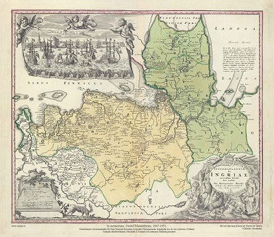
Ingermanlandiae – Homanns Erben 1734

St Petersburg och Finska viken med Kronstadt, Seskari samt Karelska- och Ingermanländska kusten. - A. Nagaev 1757.
