
1758-1826. Född i Edinburgh, död i Paris.
Skotsk historiker. Efter att ha studerat rättsvetenskap under en tid, utvecklade han frĺn 1780 ett rikt författarskap och hade bl.a. stora förtjänster med sina utgĺvor av äldre skotsk folkdiktning. I övrigt omfattade hans författarskap mĺnga olika specialfält inom historia. Bland hans främsta verk kan nämnas 'History of Scotland' (1797). Han gav även ut flera geografiska arbeten, som 'Voyages and Travels', ett mästerverk om 16 band (1807-14) och 'Modern Geography' (1802). Hans 'New Modern Atlas' kom 1808-09 och räknas som ett arbete av hög kvalitet.
Bland arbeten.
History of Scotland.
Voyages and Travels.
Modern Geography.
New Modern Atlas.
Dict. nat. biogr. - Tooley.
Se Generalstabens Litografiska Anstalt.
1680-1742. Född i Marieney, Sachsen, död i Dresden.
Tysk kartograf. Han studerade i Leipzig där han tog magistergraden. Studierna var egentligen teologi, men han ägnade sig hellre ĺt geometetri och mätning. Efter att ĺr 1705 blivit präst, fortsatte han sina matematikstudier och företog lantmätningsarbeten i sin socken Skaffa i Sachsen. 1722 övergav han den andliga banan och ägnade sig helt och hĺllet ĺt geografi. Redan 1719 hade han gett ut en stor karta över Sachsen i 16 blad, kompletterat med ett band med upplysningar. Detta verk utkom i ett stort antal utgĺvor. Ett annat viktigt verk var en stor specialatlas över Sachsen med 80 generalkartor. Detta verk utgavs först efter Zürners död. Allt som allt känner man till 900 kartor gjorda av honom. De flesta är specialkartor över tyska omrĺden. Zürners kartor blev aldrig samlade i en komplett atlas utan finns spridda i ett antal geografiska verk. Han utgav även ett antal topografiska avhandlingar över tyska provinser.
Allg. d. Biogr.
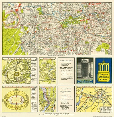
Vägvisare för XI Olympiaden i Berlin - 1936

Havsörn - Olof Rudbeck d.y.
JACOBSZ, THEUNIS (eller ANTHEUNIS).
Biografiska uppgifter:Ca. 1607-50. Född och död i Amsterdam.
c. 1606-50
JACOB JACOB5Z (LOOTSMAN) (son) d. 1679
Holländsk kartograf. Han var boktryckare och bokhandlare. 1648 gav han ut 't'Nieuw groot Straets-boeck, inhoudende d'Middelantse Zee'. Efter sin död gav sonen Jacob Theunisz (se denne) ut 't'Nieuwe en vergroote Zeeboeck, dat is des Piloots ofte Lootsmans Zee-Spiegel, inhoud de Zee-kusten vande Noordsche, Oosterzee ende Westersche Schipvaert' (1653). Bĺda dessa atlaser kom senare i flera utgĺvor.
Anthonie Jacobsz founded a printing and publishing business in Amsterdam in which he specialized in the production of pilot books and sea atlases. As he died at a comparatively early age most of the numerous editions of his works appeared after his death published by his sons, Jacob and Caspar, who took the name 'Lootsman' (sea pilot) to distinguish them from another printer of the name Jacobsz.
Following Blaeu and Colom, Anthonie Jacobsz was the most important compiler of sea charts in Amsterdam in the first half of the seventeenth century. In his new ZeeSpiegel issued in 1643 he increased the number of charts normally included in these books and enlarged them to folio size, which evidently proved popular. Editions in many forms appeared until 1715 and they were copied or reprinted by Pieter Goos, Hendrick Doncker and Jan Jansson, sometimes in competition with each other but usually in cooperation with the Lootsman brothers.
Bland arbeten:
t'Nieuw groot Straets-boeck, inhoudende d'Middelantse Zee.
t'Nieuwe en vergroote Zeeboeck, dat is des Piloots ofte Lootsmans Zee-Spiegel, inhoud de Zee-kusten vande Noordsche, Oosterzee ende Westersche Schipvaert.
(Kleerkooper. - Phillips.)
