
Död 1740.
Engelsk kartograf. Han verkade som kopparstickare och bokhandlare i London, men är främst känd för sina kartografiska arbeten. Tillsammans med kompanjonen John Maxwell gav han 1714 ut en 'English Atlas' i ett mycket stort format men utan nĺgon utsmyckning. 1719 ansvarade han för en nyutgĺva av John Ogilbys 'Britannia' (en vägkarta), och 1721 utgav han en 'New General Atlas of the World'. Kartorna i denna atlas är mindre än de i hans första och är dessutom fint utsmyckade. Senex skapade även tvĺ jordglober.
Bland arbeten.
English Atlas.
Britannia.
New General Atlas of the World.
Tooley.
1802-1854
Tecknare, avancerade som militär till överstelöjtnant, utgav en rad litografiska samlingar sĺsom de humoristiska 'Scener utur soldatlifvet' (1831-32) samt de kostymhistoriskt värdefulla 'Teckningar af de svenska kongl. ordenscostymerna' 1833) och 'Svenska krigsmaktens fordna och närvarande munderingar' (1849-53, färgtryck).
En samling färglagda teckningar 'Konung Carl XIV Johans hof- och ordenscostumer' (1844), förvaras i Kungl. biblioteket.
Arbetet 'Svenska krigsmaktens fordna och närvarande munderingar' bestĺr av 36 kolorerade och litograferade uniformsplanscher. Verket räknas till ett av de bättre uniformsverken i Sverige.
Bland arbeten.
Scener utur soldatlifvet, 1831-32
Teckningar af de svenska kongl. ordenscostymerna, 1833
Svenska krigsmaktens fordna och närvarande munderingar, 1849-53
Konung Carl XIV Johans hof- och ordenscostumer, 1844
(Sv. Uppsl.b. Malmö 1953, bd 25 sp. 672.)
Engelsk kopparstickare i slutet av 1600-talet. Han graverade kartor för atlaser och geografiska verk, av vilka kan nämnas J. Sellers 'Atlas maritimus', ett flertal utgĺvor frĺn ca. 1670, J. Speeds 'The Theatre of the Empire of Great Britain' (1676), Richard Blomes 'Cosmography' (1682 och W. Pettys 'A geographical Description of ye Kingdom of Ireland' (1689). Den sistnämnda var han även, tillsammans med J. Seller (se denne), förläggare för.
Bland arbeten.
Atlas maritimus.
The Theatre of the Empire of Great Britain.
Cosmography.
A geographical Description of ye Kingdom of Ireland.
Ph. - Tooley.
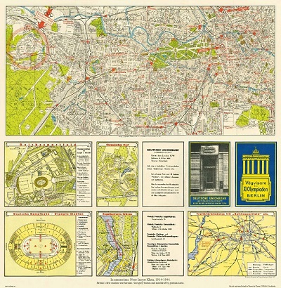
Vägvisare för XI Olympiaden i Berlin - 1936
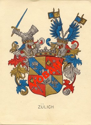
Zülich - C. H. Tersmeden ca 1900.
GERRITSZ [GERARD, GERARDUS, GHERRITSZOON van ASSUM].
Biografiska uppgifter:Hessel 1581-1632.
Gerritsz was apprenticed to W. J. Blaeu as an engraver before starting in business on his own account. He worked closely with Petrus Plancius and his merit may be judged by the fact that he was appointed Cartographer to the Dutch East India Company in preference to Blaeu and subsequently held the same position in a newly formed West India Company. With the new company he came into touch with Johannes de
Laet for whom he prepared a number of new maps of America in the latter's Nieuwe Wereldt published in 1625. His most important early work was a chart showing Henry Hudson's discoveries in his voyage of 1610-11: it is the first to give an outline of Hudson's Bay and indicates Hudson's belief that he had found a way to the North West Passage.
Engraver, cartographer, publisher and bookseller, b. Assum, apprenticed as engraver to Blaeu, Cartographer to Dutch E. India Co. 1617, fl. 1607; from 1612 using sign 'in de Paskaert' or 'sub signo Tabulae Nauticae'. Addresses: (1) opt Water bij die oude Brug [1609], (2) by die Lienbaens Brugh [1616], (3) Nieuwe Zijds Voorburgwal [1624], (4) Doelestraat [1627-32].
Engraved 17 Netherlands (1608?, lost)
Gulick Cleve 1610,
Spain 1612-(15),
Besch. van de Samoyeden Landt 1612,
Besch. van de Zeecusten van Ierlandt 1612,
engd. Blaeu's Lithuania 1613,
Russia 1613,
Italy 1617,
MS charts E. Indies, Pacific & c. 1617-22,
maps in Laet's Novus Orbis 1625,
Eendrachts' Land (W. Australia) 1627,
Rotario W. Indies & S. America 1628-32 MSS.
(Tooley.)
