
Död 1684. (?)
c. 1645-91. (?)
Koppargraverare och kartförläggare, Hugo Allards kartor baserade sig ofta pĺ kartor av J. Blaeu, N. Visscher, J. Jansonnius och F. de Wit. Han arbetade tillsammans med sin son Carel Allard som även kom att efterträda honom.
The Allard family ran an active publishing business in Amsterdam in the latter half of the seventeenth century. Most of their publications consisted of atlases made up of maps and town plans by their more famous predecessors, Blaeu, Jansson, de Wit, Visscher and others, but one of their most attractive and interesting sheet maps was of New England (Hugo Allard, 1656), based on Jansson, which included a view of New Amsterdam by C. J. Visscher.
Ca. 1590-1664. Född i Arnheim, död i Amsterdam.
Holländsk bokhandlare och kartograf. Han var först bokhandlare i sin födelsestad men flyttade till Amsterdam efter att han 1612 gift sig med en av Jodocus Hondius döttrar. Ĺr 1616 kom hans första egna kartarbeten, som var kartor över Frankrike och Italien. 1617 gav han ut Ptolomaeus geografi. Han lagade även jordglober. Tillsammans med sin svĺger Henrik Hondius gav han 1633 ut Mercator-Hondius atlasen i tvĺ band och 1635 gav han ut ytterligare tre band. Flera utgĺvor följde och det blev slutligen 6 band. 1637 gav han ut sjökartverket 'Le Nouveau Phaot de la Mer' med 51 kartor. 1657 kom 'Theatrum exhibens illustriores.. civitates' i 8 band, och under ĺren 1658-61 'Novus Atlas' i 11 band. Janssonius hade en utbredd verksamhet i Skandinavien. I Köpenhamn lĺg en betydande filial och 1647 drev han ett tryckeri med bokhandel i Stockholm. 1650 arbetade även hans son med detta, men ingen av dem upphöll sig i Stockholm. Filialen där drevs av en ställföreträdare som 1664 övertog tryckeriet för egen räkning. Janssonius...
Bland arbeten.
Le Nouveau Phaot de la Mer.
Theatrum exhibens illustriores.. civitates.
Novus Atlas.
Kleerkooper. - Klemming. - Skĺne. - Tooley.
DAUTHENDEY [DAUTHENDEIJ], CASPAR.
Architect and mathematician.
Brunswick, Blaeu 1640.
Tooley.
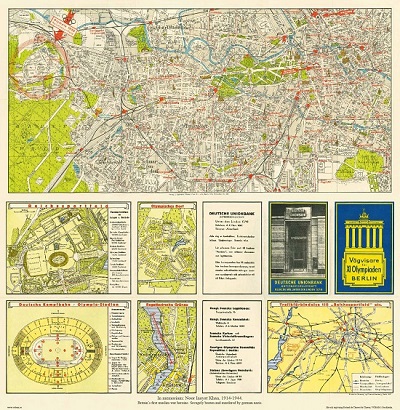
Vägvisare för XI Olympiaden i Berlin - 1936
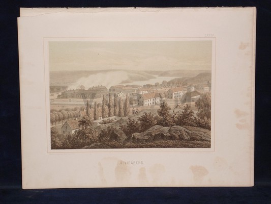
'Ĺtvidaberg.' - Gustaf Pabst 1870-1879.
Olaus Magnus text till den berömda kartan "Carta Marina".
Texten finns även pĺ katalanska, spanska och engelska.
Bureus karta över norden
Kartor och atlaser
Bilder och planschverk
Teckenförklaringar
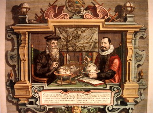
Porträtt pĺ Gerard Mercator och Jodocus Hondius.
"Striking image showing Mercator and Hondius in their idealized workshop.
This famous portrait of two of the most important mapmakers during the Golden Age of Dutch cartography was engraved by Coletta Hondius, as a tribute to her late husband, shortly after his death. Gerard Mercator is shown with his successor, Jodocus Hondius, seated at a table surrounded by the implements of their trade. The fine portrait is set within an elaborate strapwork framework that includes a wall map of Europe.
Gerard Mercator is renowned as the cartographer who created a world map representing new projections of sailing courses of constant bearing as straight lines—an innovation which, to this day, enhances the simplicity and safety of navigation. In his own day, Mercator was the world's most famous geographer. He created a number of wall maps early in his career, as well as one of the earliest modern world Atlases in 1595. Although this was the first appearance of the word Atlas in a geographical context, Mercator used it as a neologism for a treatise on the creation, history and description of the universe, not simply a collection of maps. He chose the word as a commemoration of King Atlas of Mauretania, whom he considered to be the first great geographer.
Jodocus Hondius was a Dutch engraver and cartographer. He is best known for his early maps of the New World and Europe and for continuing publication of Gerard Mercator's World Atlas. He also helped establish Amsterdam as the center of cartography in Europe in the 17th century. In England, Hondius publicized the work of Francis Drake, who had made a circumnavigation of the world in the late 1570s. In 1604, he purchased the plates of Gerard Mercator's Atlas from Mercator's grandson and continued publication of the Atlas, adding his own maps over the next several decades. Hondius later published a pocket version Atlas Minor."
