
Department of the Interior. United States Geological Survey. J. W. Powell, Director.
Washington D. C. Engraved and Printed by the U. S. Geological Survey. Bailey Willis, Editor of Geological maps. S. J. KŁbel, Chief Engraver.
Flerfšrgslitografi.
Mapp med text pŚ insidan samt ytterligare fyra sidor text.
Fyra kartor, 'Topography', 'Areal Geology', 'Economic Geology', 'Structure Sections'.
Storlek: 48x55 cm. Mappens bredd x hŲjd.
Pris: 600 SEK - 26666
'Geologic Atlas of the United States. Placerville Folio. California.' - Washington D.C. 1894.
Department of the Interior. United States Geological Survey. J. W. Powell, Director.
Washington D. C. Engraved and Printed by the U. S. Geological Survey. Bailey Willis, Editor of Geological maps. S. J. KŁbel, Chief Engraver.
Flerfšrgslitografi.
Mapp med text pŚ insidan samt ytterligare fyra sidor text.
Fyra kartor, 'Topography', 'Areal Geology', 'Economic Geology', 'Structure Sections'.
Storlek: 48x55 cm. Mappens bredd x hŲjd.
Pris: 600 SEK - 26663
Department of the Interior. United States Geological Survey. J. W. Powell, Director.
Washington D. C. Engraved and Printed by the U. S. Geological Survey. Bailey Willis, Editor of Geological maps. S. J. KŁbel, Chief Engraver.
Flerfšrgslitografi.
Mapp med text pŚ insidan samt ytterligare sex sidor text.
Fyra kartor, 'Topography', 'Areal Geology', 'Economic Geology', 'Structure Sections'.
En tabell, 'Columnar Sections'.
Storlek: 48x55 cm. Mappens bredd x hŲjd.
Pris: 600 SEK - 26660

Die VEREINIGTEN STAATEN von NORD-AMERICA
Eentworfen und gezeichnet von C. F. Wieland.
Infšlld karta: 'Plan von Washington mit Georgetown.'
Weimar 1834. Verlage des Geograph. Instituts.
Storlek: 62x46 cm.
Kraftfull gršnskolorering.
Pris: 4000 SEK - 26075 - Se bild.
Department of the Interior. United States Geological Survey. J. W. Powell, Director.
Washington D. C. Engraved and Printed by the U. S. Geological Survey. Bailey Willis, Editor of Geological maps. S. J. KŁbel, Chief Engraver.
Flerfšrgslitografi.
Mapp med text pŚ insidan samt ytterligare fyra sidor text.
Fyra kartor, 'Topography', 'Areal Geology', 'Economic Geology', 'Structure Sections'.
Storlek: 48x55 cm. Mappens bredd x hŲjd.
Pris: 600 SEK - 26664
USA. - 1903-1913. - ur Le Petit Journal.

USA
4 fŲrsta-sidor 1903-1913 och 6 supplement-sidor utan Śrtal.
Totalt 10 motiv.
Storlek: 30x42 cm. Omvšxlande stŚende och liggande.
Pris: 2000 SEK - 26655 - Se bild.
Le Petit Journal, morgontidning i Paris och lšnge en av de 'fyra stora'. Grundad 1863. PŚ 1930-talet nationalistiskt eldkorsorgan. Tidningen upphŲrde i samband med andra všrldskriget.
Bilderna/motiven šr klart kitschiga och det šr just pŚ grund av detta som de blir mer och mer eftersŲkta.
'Geologic Atlas of the United States. Sewanee Folio. Tennessee.' - Washington D.C. 1894.
Department of the Interior. United States Geological Survey. J. W. Powell, Director.
Washington D. C. Engraved and Printed by the U. S. Geological Survey. Bailey Willis, Editor of Geological maps. S. J. KŁbel, Chief Engraver.
Flerfšrgslitografi.
Mapp med text pŚ insidan samt ytterligare fyra sidor text.
Fyra kartor, 'Topography', 'Areal Geology', 'Economic Geology', 'Structure Sections'.
En tabell, 'Columnar Sections'.
Storlek: 48x55 cm. Mappens bredd x hŲjd.
Pris: 600 SEK - 26656
'Geologic Atlas of the United States. Jackson Folio. California.' - Washington D.C. 1894.
Department of the Interior. United States Geological Survey. J. W. Powell, Director.
Washington D. C. Engraved and Printed by the U. S. Geological Survey. Bailey Willis, Editor of Geological maps. S. J. KŁbel, Chief Engraver.
Flerfšrgslitografi.
Mapp med text pŚ insidan samt ytterligare sex sidor text.
Fyra kartor, 'Topography', 'Areal Geology', 'Economic Geology', 'Structure Sections'.
Storlek: 48x55 cm. Mappens bredd x hŲjd.
Pris: 600 SEK - 26661
'Geologic Atlas of the United States. Ringgold Folio. Georgia - Tennessee.' - Washington D.C. 1894.
Department of the Interior. United States Geological Survey. J. W. Powell, Director.
Washington D. C. Engraved and Printed by the U. S. Geological Survey. Bailey Willis, Editor of Geological maps. S. J. KŁbel, Chief Engraver.
Mapp med text pŚ insidan samt ytterligare fyra sidor text.
Fyra kartor, 'Topography', 'Areal Geology', 'Economic Geology', 'Structure Sections'.
En tabell, 'Columnar Sections'.
Storlek: 48x55 cm. Mappens bredd x hŲjd.
Pris: 600 SEK - 26659

Der Oestliche Theil der VEREINIGTEN STAATEN von NORD AMERICA nebst dem bewohntesten Theile von Canada.
Entworfen und gezeichnet von C. F. Weiland.
Skala: 1:5.140.000
Infšllda kartor: 'Umgebungen von Baltimore und Washington.', 'Umgebungen von Boston.', 'Umgebungen von New-York.', 'Umgebungen von Philadelphia und Trenton.'
Weimar 1835. Verlage des Geograph. Instituts.
Storlek: 50x59 cm.
Kraftfull gršnskolorering.
Pris: 4500 SEK - 26076 - Se bild.
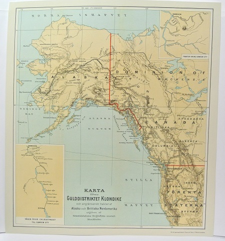
Gulddistriktet Klondike - ca 1897.

Flšder, Sambucus nigra - Lindman, C. A. M, Bilder ur Nordens Flora 1917-26.
Boston - John William Hill, ca 1850.

Boston
Gravyr tryckt frŚn originalplŚten och handkolorerad.
Storlek: 102x71 cm. Bildytans bredd x hŲjd.
En mycket dekorativ panoramavy Ųver Boston och dess hamn frŚn tiden fŲre inbŲrdeskriget.
Pris: 6000 SEK - 26654 - Se bild.
Amerika - Nordamerika - USA -
Pris med bred spansk vacker mahognyinspirerad ram: 9.000:-
