
Nya Sverige. - P. Lindstr÷m, T. Campanius Holm 1655.

Nova Svecia hodie dicta Pennsylvania.
Anno 1654 och 1655 õr denna Nove Svecie charta med dess Riviers och Landz situation ock beskaffenhet aftagen och till Carts f÷rd af P. Lindstr÷m ingin. fortif..
Originalet frÕn Thomas Campanius Holms bok, 1702.
Faksimil pÕ akvarellpapper och helt handkolorerad.
Uppf÷rstorad: 25x55 cm. Pris: 1.200:-
Originalstorlek: 17x36,5 cm. Pris: 900:-
Pris: 900 SEK - 26645 - Se bild.
'New Map of Boston...' - 1883.
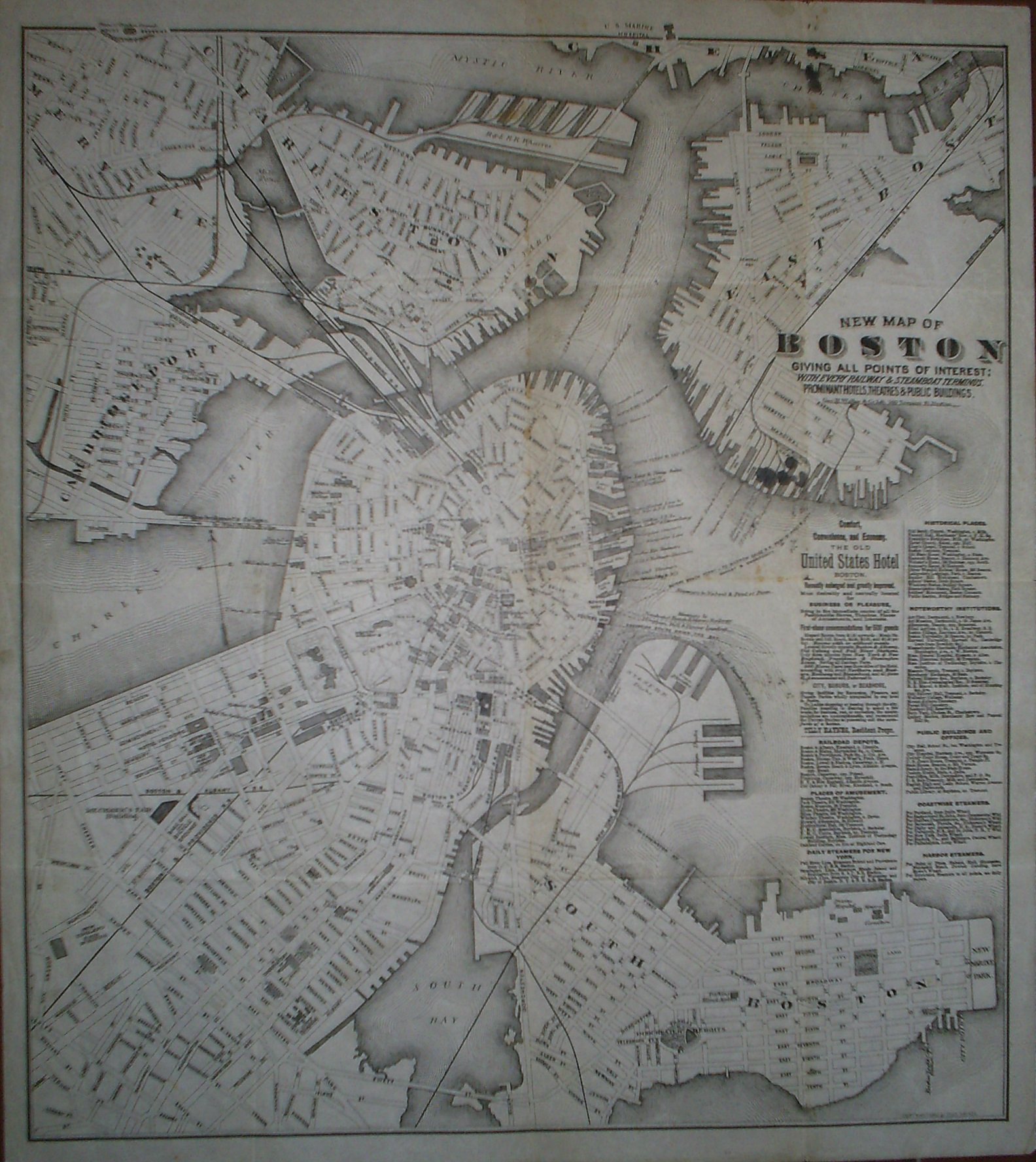
New Map of Boston giving all points of interest: with every railway & steamboat terminus, prominant hotels, theatres & public buildings.
Geo. H. Walker & Co Lith. 160 Tremont St. Boston.
Copyright 1883 by Tilly Haynes.
Litograferad karta.
Storlek: 44x49 cm. Kartytans bredd x h÷jd.
Kartan har varit vikt. Med smÕhÕl i vikningen. Fyra smõrre blõckflõckar under titeln samt tre stycken i kartans ÷vre kant. Svag bruntoning i mittvecket.
Karta ÷ver Boston.
Pris: 2000 SEK - 26650 - Se bild.
Med reklam f÷r 'The Old United States Hotel Boston' samt lista ÷ver kommunikationer, sevõrdheter, historiska platser med mera.
'Geologic Atlas of the United States. Chattanooga Folio. Tennessee.' - Washington D.C. 1894.
Department of the Interior. United States Geological Survey. J. W. Powell, Director.
Washington D. C. Engraved and Printed by the U. S. Geological Survey. Bailey Willis, Editor of Geological maps. S. J. K³bel, Chief Engraver.
Flerfõrgslitografi.
Mapp med text pÕ insidan samt ytterligare fyra sidor text.
Fyra kartor, 'Topography', 'Areal Geology', 'Economic Geology', 'Structure Sections'.
En tabell, 'Columnar Sections'.
Storlek: 48x55 cm. Mappens bredd x h÷jd.
Pris: 600 SEK - 26658
Carte de la Nouvelle Angleterre,...' - Bellin 1757.

Carte de la Nouvelle Angleterre, Nouvelle Yorck, et Pensilvanie. Pour servir Ó l'Histoire Gķnķrale des Voyages.
Par M. B. Ing. de la Mare. 1757.
Koppargraverad karta med vacker handkolorering frÕn tiden.
Kartan har varit vikt, lite bruntonad i marginalerna.
Storlek: 29x20 cm. Kartytan bredden x h÷jden.
Pris: 2000 SEK - 26647 - Se bild.
'Habits et Maisons des Floridiens.' - 1700-talets mitt.
Habits et Maisons des Floridiens.
Koppargraverad bild.
Storlek: 7x12 cm. Bildytans bredd x h÷jd.
Bild pÕ mõnniskor, hus och palmer i Florida.
Pris: 500 SEK - 26652
'Geologic Atlas of the United States. Jackson Folio. California.' - Washington D.C. 1894.
Department of the Interior. United States Geological Survey. J. W. Powell, Director.
Washington D. C. Engraved and Printed by the U. S. Geological Survey. Bailey Willis, Editor of Geological maps. S. J. K³bel, Chief Engraver.
Flerfõrgslitografi.
Mapp med text pÕ insidan samt ytterligare sex sidor text.
Fyra kartor, 'Topography', 'Areal Geology', 'Economic Geology', 'Structure Sections'.
Storlek: 48x55 cm. Mappens bredd x h÷jd.
Pris: 600 SEK - 26661
'Cataracte de Niagara.' - 1700-tal.

Cataracte de Niagara.
Koppargraverad vy.
Storlek: 14x13 cm. Bildytans bredd x h÷jd.
Bilden har varit vikt.
Vy ÷ver Niagarafallen.
Pris: 800 SEK - 26651 - Se bild.
Department of the Interior. United States Geological Survey. J. W. Powell, Director.
Washington D. C. Engraved and Printed by the U. S. Geological Survey. Bailey Willis, Editor of Geological maps. S. J. K³bel, Chief Engraver.
Flerfõrgslitografi.
Mapp med text pÕ insidan samt ytterligare fyra sidor text.
Fyra kartor, 'Topography', 'Areal Geology', 'Economic Geology', 'Structure Sections'.
Storlek: 48x55 cm. Mappens bredd x h÷jd.
Pris: 600 SEK - 26666
'Geologic Atlas of the United States. Kingston Folio. Tennessee.' - Washington D.C. 1894.
Department of the Interior. United States Geological Survey. J. W. Powell, Director.
Washington D. C. Engraved and Printed by the U. S. Geological Survey. Bailey Willis, Editor of Geological maps. S. J. K³bel, Chief Engraver.
Flerfõrgslitografi.
Mapp med text pÕ insidan samt ytterligare fyra sidor text.
Fyra kartor, 'Topography', 'Areal Geology', 'Economic Geology', 'Structure Sections'.
En tabell, 'Columnar Sections'.
Storlek: 48x55 cm. Mappens bredd x h÷jd.
Pris: 600 SEK - 26657
'Geologic Atlas of the United States. Sacramento Folio. California.' - Washington D.C. 1894.
Department of the Interior. United States Geological Survey. J. W. Powell, Director.
Washington D. C. Engraved and Printed by the U. S. Geological Survey. Bailey Willis, Editor of Geological maps. S. J. K³bel, Chief Engraver.
Flerfõrgslitografi.
Mapp med text pÕ insidan samt ytterligare fyra sidor text.
Fyra kartor, 'Topography', 'Areal Geology', 'Economic Geology', 'Structure Sections'.
Storlek: 48x55 cm. Mappens bredd x h÷jd.
Pris: 600 SEK - 26662
Ingermanlandiae ¢ Homanns Erben 1734

Skavgrõs, Equisetum hiemale - Lindman, C. A. M, Bilder ur Nordens Flora 1917-26.
New York - John William Hill, ca 1850.

New York
Gravyr tryckt frÕn originalplÕten och handkolorerad.
Storlek: 142x89 cm. Bildytans bredd x h÷jd.
En mycket dekorativ panoramavy ÷ver Manhattan med East River i f÷rgrunden och Hudsonfloden i bakgrunden.
Pris: 8000 SEK - 26653 - Se bild.
Amerika - Nordamerika - USA -
Pris med bred spansk vacker mahognyinspirerad ram: 15.000:-
