
Department of the Interior. United States Geological Survey. J. W. Powell, Director.
Washington D. C. Engraved and Printed by the U. S. Geological Survey. Bailey Willis, Editor of Geological maps. S. J. Kübel, Chief Engraver.
Flerfärgslitografi.
Mapp med text pĺ insidan samt ytterligare fyra sidor text.
Fyra kartor, 'Topography', 'Areal Geology', 'Economic Geology', 'Structure Sections'.
Storlek: 48x55 cm. Mappens bredd x höjd.
Pris: 600 SEK - 26664
'Geologic Atlas of the United States. Chattanooga Folio. Tennessee.' - Washington D.C. 1894.
Department of the Interior. United States Geological Survey. J. W. Powell, Director.
Washington D. C. Engraved and Printed by the U. S. Geological Survey. Bailey Willis, Editor of Geological maps. S. J. Kübel, Chief Engraver.
Flerfärgslitografi.
Mapp med text pĺ insidan samt ytterligare fyra sidor text.
Fyra kartor, 'Topography', 'Areal Geology', 'Economic Geology', 'Structure Sections'.
En tabell, 'Columnar Sections'.
Storlek: 48x55 cm. Mappens bredd x höjd.
Pris: 600 SEK - 26658
'Geologic Atlas of the United States. Sacramento Folio. California.' - Washington D.C. 1894.
Department of the Interior. United States Geological Survey. J. W. Powell, Director.
Washington D. C. Engraved and Printed by the U. S. Geological Survey. Bailey Willis, Editor of Geological maps. S. J. Kübel, Chief Engraver.
Flerfärgslitografi.
Mapp med text pĺ insidan samt ytterligare fyra sidor text.
Fyra kartor, 'Topography', 'Areal Geology', 'Economic Geology', 'Structure Sections'.
Storlek: 48x55 cm. Mappens bredd x höjd.
Pris: 600 SEK - 26662
'Geologic Atlas of the United States. Ringgold Folio. Georgia - Tennessee.' - Washington D.C. 1894.
Department of the Interior. United States Geological Survey. J. W. Powell, Director.
Washington D. C. Engraved and Printed by the U. S. Geological Survey. Bailey Willis, Editor of Geological maps. S. J. Kübel, Chief Engraver.
Mapp med text pĺ insidan samt ytterligare fyra sidor text.
Fyra kartor, 'Topography', 'Areal Geology', 'Economic Geology', 'Structure Sections'.
En tabell, 'Columnar Sections'.
Storlek: 48x55 cm. Mappens bredd x höjd.
Pris: 600 SEK - 26659
'New Map of Boston...' - 1883.
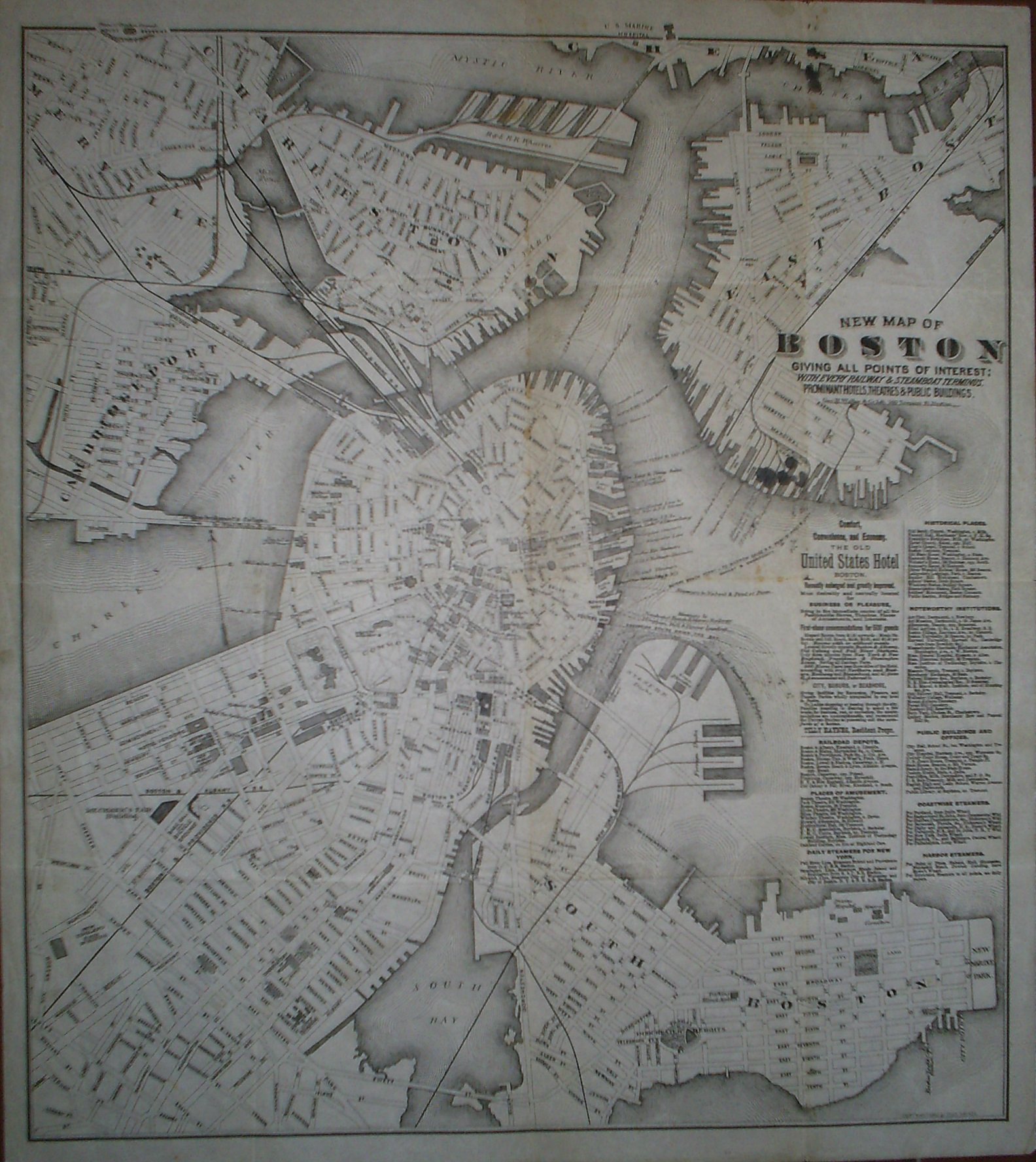
New Map of Boston giving all points of interest: with every railway & steamboat terminus, prominant hotels, theatres & public buildings.
Geo. H. Walker & Co Lith. 160 Tremont St. Boston.
Copyright 1883 by Tilly Haynes.
Litograferad karta.
Storlek: 44x49 cm. Kartytans bredd x höjd.
Kartan har varit vikt. Med smĺhĺl i vikningen. Fyra smärre bläckfläckar under titeln samt tre stycken i kartans övre kant. Svag bruntoning i mittvecket.
Karta över Boston.
Pris: 2000 SEK - 26650 - Se bild.
Med reklam för 'The Old United States Hotel Boston' samt lista över kommunikationer, sevärdheter, historiska platser med mera.
New York - John William Hill, ca 1850.

New York
Gravyr tryckt frĺn originalplĺten och handkolorerad.
Storlek: 142x89 cm. Bildytans bredd x höjd.
En mycket dekorativ panoramavy över Manhattan med East River i förgrunden och Hudsonfloden i bakgrunden.
Pris: 8000 SEK - 26653 - Se bild.
Pris med bred spansk vacker mahognyinspirerad ram: 15.000:-
'Habits et Maisons des Floridiens.' - 1700-talets mitt.
Habits et Maisons des Floridiens.
Koppargraverad bild.
Storlek: 7x12 cm. Bildytans bredd x höjd.
Bild pĺ människor, hus och palmer i Florida.
Pris: 500 SEK - 26652
USA. - 1903-1913. - ur Le Petit Journal.

USA
4 första-sidor 1903-1913 och 6 supplement-sidor utan ĺrtal.
Totalt 10 motiv.
Storlek: 30x42 cm. Omväxlande stĺende och liggande.
Pris: 2000 SEK - 26655 - Se bild.
Le Petit Journal, morgontidning i Paris och länge en av de 'fyra stora'. Grundad 1863. Pĺ 1930-talet nationalistiskt eldkorsorgan. Tidningen upphörde i samband med andra världskriget.
Bilderna/motiven är klart kitschiga och det är just pĺ grund av detta som de blir mer och mer eftersökta.
Boston - John William Hill, ca 1850.

Boston
Gravyr tryckt frĺn originalplĺten och handkolorerad.
Storlek: 102x71 cm. Bildytans bredd x höjd.
En mycket dekorativ panoramavy över Boston och dess hamn frĺn tiden före inbördeskriget.
Pris: 6000 SEK - 26654 - Se bild.
Pris med bred spansk vacker mahognyinspirerad ram: 9.000:-
Department of the Interior. United States Geological Survey. J. W. Powell, Director.
Washington D. C. Engraved and Printed by the U. S. Geological Survey. Bailey Willis, Editor of Geological maps. S. J. Kübel, Chief Engraver.
Flerfärgslitografi.
Mapp med text pĺ insidan samt ytterligare fyra sidor text.
Fyra kartor, 'Topography', 'Areal Geology', 'Economic Geology', 'Structure Sections'.
Storlek: 48x55 cm. Mappens bredd x höjd.
Pris: 600 SEK - 26666
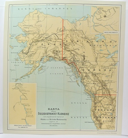
Gulddistriktet Klondike - ca 1897.

Hängpiggfrö, Lappula Deflexa (Wg) Garcke - Lindman, C. A. M, Bilder ur Nordens Flora 1917-26.
'Plan of the City of Washington.' - Ellicott 1792.
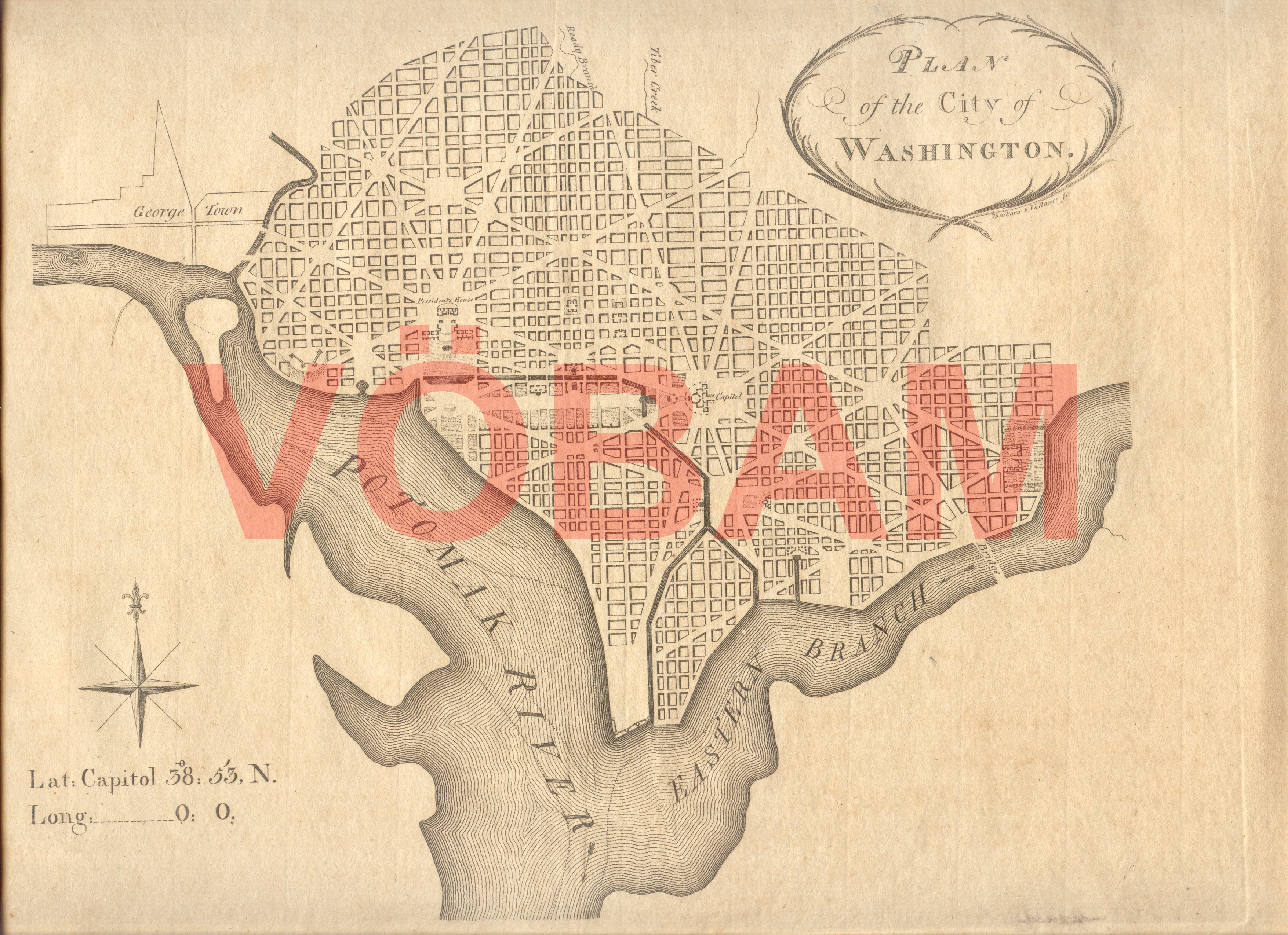
Plan of the City of Washington.
Tryckt i Philadelphia mars 1792 av Thackara och Vallance.
Storlek: 30x22 cm. Kartplĺtens bredd x höjd. Breda marginaler.
Utomordentligt rar. / Very rare.
Karta över Washington.
Pris: 110000 SEK - 26649 - Se bild.
Amerika - Nordamerika - USA - Washington DC
Denna karta lät man trycka i första hand för att kunna visa var kvarter, markomrĺden o.s.v. i den nya huvudstaden lĺg för de presumtiva köpare man sĺlde tomter till.
This map was printed primarily to show future buyers of building lots in the new capital where these lots actually was located in the city. It would take another couple of months until the first official city plan was published in november 1792 by Thackara and Vallance.
