
Norra Ryssland. - Blaeu 1643/44.

RUSSIAE, vulgo MOSCOVIA dictae, Partes Septentrionalis et Orientalis.
Auctore Isaaco Massa.
Apud Ioannem et Cornelium Blaeu.
Koppargraverad och handkolorerad karta med originalkolorerad kartusch och vapensköld.
Storlek: 54x42 cm. Kartytans bredd x höjd.
Verso: Fransk text.
Kartan har varit vikt. Fläck i nedre högra hörnet.
Kartan visar norra Ryssland från Ishavet i norr till Volga i syd med städerna Tver, Jaroslavl, Nizhnij Novgorod och Kazan. Kartan sträcker sig in i Sibirien till floden Ob samt längs norra kusten förbi flodens mynning.
Pris: 5000 SEK - 26211 - Se bild.
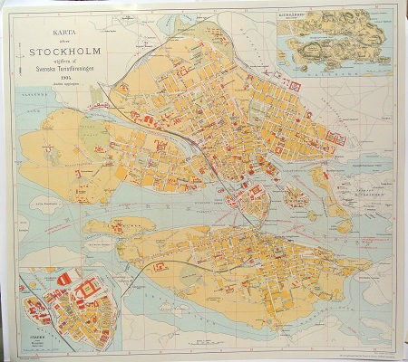
Karta öfver Stockholm. - 1904.

Buskviol, Viola hirta - Lindman, C. A. M, Bilder ur Nordens Flora 1917-26.
'Nova Zemlja' - Blaeu. 1600-talets första hälft.


Nova Zemlja -
Amsterdam 1600-talets första hälft..
Fransk text på baksidan.
Storlek: 50x38 cm. Bildytans mått.
Kolorerad.
Vikning i mitten. Litet hål i kartans övre vänstra hörn.
These scarce maps of Novaya Zemlya were only published in Blaeu's Atlas Maior. They were drawn from Linschoten and Barents' description of their explorations of the Arctic Sea (1594-97) in search of a Northeast Passage to Asia. The map of Nova Zemla shows the Russian coastline and the western coastline of Novaya Zemlya. Barents' stranded ship and winter camp of 1596 are depicted at the north end of the island. On the verso is a beautiful illustration of walruses.
Pris: 4000 SEK - 26223 - Se bild.
Europa - Östra Europa - Ryssland - Novaja Zemlja
På baksidan av kartan, kolorerad bild av en valross med unge och ett fartyg i bakgrunden, storlek 22x17 cm.
